
Outdoor Adventures in the Twin Cities
Hiking & Biking
Nokomis-Minnesota River Regional Trail contributes 7 miles to the Twin Cities’ extensive network of regional trails. The paved path is 10-foot wide, providing room for a variety of trail users including bicyclists, joggers, walkers and inline skaters. It’s a north-south trail across three communities: Minneapolis, Richfield and Bloomington. As it travels south, it goes through residential neighborhoods, into parks and near retail and entertainment destinations including the famous Mall of America in Bloomington, and the Minneapolis-St. Paul International Airport. It also links with other trails in the system: at its north end it joins the Grand Rounds Scenic Byway, a 50-mile network of trails. In Richfield, it connects to the Nine Mile Creek Regional Trail. While most crossings are at grade, there are two bridges, one over State Route 62 and the other spanning I-494.
Parking and Trail Access
You could choose to park at one of the parks along the trail:
Taft Park
Washington Park
Wright’s Lake Park
Nokomis-Minnesota River Regional Trail
Nokomis-Minnesota River Regional TrailNokomis-Minnesota River Regional Trail contributes 7 miles to the Twin Cities’ extensive network of regional trails. The paved path is 10-foot wide, providing room for a variety of trail users including bicyclists, joggers, walkers and inline skaters. It’s a north-south trail across three communities: Minneapolis, Richfield and Bloomington. As it travels south, it goes through residential neighborhoods, into parks and near retail and entertainment destinations including the famous Mall of America in Bloomington, and the Minneapolis-St. Paul International Airport. It also links with other trails in the system: at its north end it joins the Grand Rounds Scenic Byway, a 50-mile network of trails. In Richfield, it connects to the Nine Mile Creek Regional Trail. While most crossings are at grade, there are two bridges, one over State Route 62 and the other spanning I-494.
Parking and Trail Access
You could choose to park at one of the parks along the trail:
Taft Park
Washington Park
Wright’s Lake Park
At the heart of Minneapolis’ world-class trail system is the Grand Rounds Scenic Byway, a series of interconnected parks and parkways that loop around the city, acting as a key connector to the entire network of city parks and trails and more than 300 miles of regional trails. The 7 segments are connected by 50 miles of paved pedestrian trails and mostly separated bike paths, as well as 55 miles of driving parkways that give the Grand Rounds its status as a national scenic byway.
From the Grand Rounds, travelers can access the city’s numerous parks and trails. It is this connectivity that allows residents to use the Grand Rounds trails not just for recreation but for daily travel. The Grand Rounds trails are cleared by six o’clock every morning in the winter as many commuters depend on them to walk and bike to work.
The Grand Rounds travels through 7 districts: Chain of Lakes (13.3 miles), Minnehaha (12.6 miles), The Mississippi River (9.2 miles), Downtown Riverfront (1.2 miles), Northeast (6 miles), Victory Memorial (3.8 miles), and Theodore Wirth Park (4 miles).
8 personas locales recomiendan
Grand Rounds Scenic Byway
Grand Rounds Scenic BywayAt the heart of Minneapolis’ world-class trail system is the Grand Rounds Scenic Byway, a series of interconnected parks and parkways that loop around the city, acting as a key connector to the entire network of city parks and trails and more than 300 miles of regional trails. The 7 segments are connected by 50 miles of paved pedestrian trails and mostly separated bike paths, as well as 55 miles of driving parkways that give the Grand Rounds its status as a national scenic byway.
From the Grand Rounds, travelers can access the city’s numerous parks and trails. It is this connectivity that allows residents to use the Grand Rounds trails not just for recreation but for daily travel. The Grand Rounds trails are cleared by six o’clock every morning in the winter as many commuters depend on them to walk and bike to work.
The Grand Rounds travels through 7 districts: Chain of Lakes (13.3 miles), Minnehaha (12.6 miles), The Mississippi River (9.2 miles), Downtown Riverfront (1.2 miles), Northeast (6 miles), Victory Memorial (3.8 miles), and Theodore Wirth Park (4 miles).
Minnesota’s Hiawatha LRT Trail runs along a north-south route paralleling both Hiawatha Avenue and the Metro Transit Blue Line in Minneapolis. The trail connects downtown Minneapolis and the vibrant Cedar-Riverside neighborhood in the north to Minnehaha Creek, Minnehaha Park, and the former site of the Longfellow Zoological Gardens in the south.
The trail begins just one block north of the site of the former Metrodome (demolished in 2014) at Norm McGrew Place and South Third Street in the Downtown East neighborhood. Bike lanes along South Third Street and South Fourth Street (as well as an extension from Chicago Avenue) allow for a trek deeper into the heart of Minneapolis. Upon completion of the new Vikings stadium, access, lane routes, and area parking may affect this downtown trailhead.
Continuing south from the former Metrodome site, the Hiawatha Trail crosses busy I-35 West on the light rail overpass and under I-94 just north of the large Metro Transit storage and maintenance facility. The trail cuts through a portion of the Cedar-Riverside neighborhood as it continues southward, finally getting into a more residential setting once it crosses Franklin Avenue. At East 24th Street, a bicycle and pedestrian bridge over Hiawatha Avenue/MN 55 carries trail users to the Phillips community of Minneapolis.
Just past East 26th Street, the stunning Martin Olav Sabo Bridge connects the Hiawatha Trail with the popular Midtown Greenway over Hiawatha Avenue. Those wishing to continue south on the Hiawatha Trail should cross to the western side of the road, where the trail surface changes from asphalt to concrete. The section of trail from East 28th Street south to East 32nd Street is little more than a sidewalk; trail users should exercise caution when navigating this section. Fortunately, Minneapolis has targeted this portion of the Hiawatha Trail for improvement in the future.
For most of the rest of its route, the trail is wedged between the light rail line and Hiawatha Avenue. The light rail station and platforms at 38th Street and 46th Street each have Nice Ride bike rental stations. At East 46th Street, trail users cross the tracks and pick up the trail on the western side of the Metro Transit Blue Line as it continues running parallel to MN 55/Hiawatha Avenue.
After just one block, the trail ends at Minnehaha Parkway in the Minnehaha neighborhood, where a short walk, run, or bike along the road leads to the appropriately named Minnehaha Trail.
Both the Hiawatha and West River Parkway Trail link the Minnehaha Park area with the eastern side of downtown Minneapolis. The Hiawatha Trail offers a fast, direct, no-frills pathway alongside high-traffic streets and railroad tracks just south of downtown.
Parking and Trail Access
From I-35W, take Exit 13. Head east on E. 46th St., and go 1.4 miles. Turn right onto Cedar Ave., and go 0.3 mile. Turn left onto E. Minnehaha Pkwy., and go 1.6 miles. Turn right into the parking lot.
Parking can be found in the southern residential section once E. Minnehaha Pkwy. crosses over Hiawatha Ave. There is also metered street parking along S. Minnehaha Drive at Minnehaha Falls, in addition to a number of parking lots in downtown Minneapolis. Parking is also available along neighborhood streets that intersect with the trail south of Franklin Ave. to the end of the trail.
Hiawatha LRT Trail
Hiawatha LRT TrailMinnesota’s Hiawatha LRT Trail runs along a north-south route paralleling both Hiawatha Avenue and the Metro Transit Blue Line in Minneapolis. The trail connects downtown Minneapolis and the vibrant Cedar-Riverside neighborhood in the north to Minnehaha Creek, Minnehaha Park, and the former site of the Longfellow Zoological Gardens in the south.
The trail begins just one block north of the site of the former Metrodome (demolished in 2014) at Norm McGrew Place and South Third Street in the Downtown East neighborhood. Bike lanes along South Third Street and South Fourth Street (as well as an extension from Chicago Avenue) allow for a trek deeper into the heart of Minneapolis. Upon completion of the new Vikings stadium, access, lane routes, and area parking may affect this downtown trailhead.
Continuing south from the former Metrodome site, the Hiawatha Trail crosses busy I-35 West on the light rail overpass and under I-94 just north of the large Metro Transit storage and maintenance facility. The trail cuts through a portion of the Cedar-Riverside neighborhood as it continues southward, finally getting into a more residential setting once it crosses Franklin Avenue. At East 24th Street, a bicycle and pedestrian bridge over Hiawatha Avenue/MN 55 carries trail users to the Phillips community of Minneapolis.
Just past East 26th Street, the stunning Martin Olav Sabo Bridge connects the Hiawatha Trail with the popular Midtown Greenway over Hiawatha Avenue. Those wishing to continue south on the Hiawatha Trail should cross to the western side of the road, where the trail surface changes from asphalt to concrete. The section of trail from East 28th Street south to East 32nd Street is little more than a sidewalk; trail users should exercise caution when navigating this section. Fortunately, Minneapolis has targeted this portion of the Hiawatha Trail for improvement in the future.
For most of the rest of its route, the trail is wedged between the light rail line and Hiawatha Avenue. The light rail station and platforms at 38th Street and 46th Street each have Nice Ride bike rental stations. At East 46th Street, trail users cross the tracks and pick up the trail on the western side of the Metro Transit Blue Line as it continues running parallel to MN 55/Hiawatha Avenue.
After just one block, the trail ends at Minnehaha Parkway in the Minnehaha neighborhood, where a short walk, run, or bike along the road leads to the appropriately named Minnehaha Trail.
Both the Hiawatha and West River Parkway Trail link the Minnehaha Park area with the eastern side of downtown Minneapolis. The Hiawatha Trail offers a fast, direct, no-frills pathway alongside high-traffic streets and railroad tracks just south of downtown.
Parking and Trail Access
From I-35W, take Exit 13. Head east on E. 46th St., and go 1.4 miles. Turn right onto Cedar Ave., and go 0.3 mile. Turn left onto E. Minnehaha Pkwy., and go 1.6 miles. Turn right into the parking lot.
Parking can be found in the southern residential section once E. Minnehaha Pkwy. crosses over Hiawatha Ave. There is also metered street parking along S. Minnehaha Drive at Minnehaha Falls, in addition to a number of parking lots in downtown Minneapolis. Parking is also available along neighborhood streets that intersect with the trail south of Franklin Ave. to the end of the trail.
Minnehaha Trail connects two popular parks in the Twin Cities as it follows Minnehaha Creek through a corridor that is a mix of woodland and open areas. It is sometimes referred to as Minnehaha Creek Trail.
At the trail’s southern end, in Saint Paul, is Fort Snelling State Park, which offers many recreational opportunities, including canoeing, swimming, and fishing, as well as trails for hiking, biking, and cross-country skiing. At the trail’s northern end in Minneapolis, is the 53-foot Minnehaha Falls, one of the city’s most stunning, must-see natural features. The surrounding Minnehaha Falls Regional Park is also beautiful, with limestone bluffs and river overlooks.
The northern end of the Minnehaha Trail is within blocks of three major trails: the Grand Rounds Scenic Byway System that encircles the Twin Cities and includes two trails that head into the heart of downtown; the Hiawatha LRT Trail’s southern trailhead, which is just two blocks to the west along Minnehaha Parkway; and the southern terminus of the West River Parkway Trail, which begins at the eastern end of Godfrey Parkway/West River Parkway and skirts along the northern boundary of Minnehaha Falls for a few blocks to the entrance to Lock and Dam No. 1 (small parking lot) on the Mississippi River.
As the trail exits the Minnehaha Falls park, it follows a wooded corridor along the bluff line above the Mississippi River, offering frequent views of the channel below. It comes into Fort Snelling State Park just north of the visitor center and blends into the Snelling Lake Trail, one of many trails that weave through the park. The Minnehaha Trail ends at the park’s south entrance.
Yet another trail spur at the south end of the Minnehaha Falls Regional Park segment of the trail crosses the MN 55 bridge into Mendota, where trail users can pick up the Big Rivers Regional Trail.
Two Nice Ride bike-rental stations are located along this trail: one near the Coldwater Spring section of the trail at Minnehaha Falls and one at the visitor center in Fort Snelling State Park.
Parking and Trail Access
To reach southern parking near Fort Snelling State Park, take I-94 to Exit 237. Head south on Cretin Ave. N., and go 2.5 miles. Turn left onto W. Highland Pkwy., and in 0.3 mile turn right onto Cleveland Ave. S. Go 1.4 miles, and turn left onto Mississippi River Blvd. S. In 0.4 mile turn left onto the ramp for MN 5 W. In 2 miles, take the Post Road exit. Turn left onto Post Road; parking will be on the right in 0.5 mile.
Additional parking can be found along S. Minnehaha Drive south of the John H. Stevens House, along S. Minnehaha Drive farther south near where it intersects Minnehaha Ave., along Hiawatha Ave. near where it intersects with E. 54th St., and just off Godfrey Pkwy./W. River Pkwy. at the entrance to Lock and Dam No. 1.
The Wabun Picnic Area at Minnehaha Regional Park also has ample parking and facilities. Take I-94 to Exit 237. Head south on Cretin Ave. N., and go 2.6 miles. Turn right onto Ford Pkwy., and in 0.8 mile turn left onto 46th Ave. S. In 0.2 mile turn left into the picnic area.

Minnehaha Trail
Minnehaha TrailMinnehaha Trail connects two popular parks in the Twin Cities as it follows Minnehaha Creek through a corridor that is a mix of woodland and open areas. It is sometimes referred to as Minnehaha Creek Trail.
At the trail’s southern end, in Saint Paul, is Fort Snelling State Park, which offers many recreational opportunities, including canoeing, swimming, and fishing, as well as trails for hiking, biking, and cross-country skiing. At the trail’s northern end in Minneapolis, is the 53-foot Minnehaha Falls, one of the city’s most stunning, must-see natural features. The surrounding Minnehaha Falls Regional Park is also beautiful, with limestone bluffs and river overlooks.
The northern end of the Minnehaha Trail is within blocks of three major trails: the Grand Rounds Scenic Byway System that encircles the Twin Cities and includes two trails that head into the heart of downtown; the Hiawatha LRT Trail’s southern trailhead, which is just two blocks to the west along Minnehaha Parkway; and the southern terminus of the West River Parkway Trail, which begins at the eastern end of Godfrey Parkway/West River Parkway and skirts along the northern boundary of Minnehaha Falls for a few blocks to the entrance to Lock and Dam No. 1 (small parking lot) on the Mississippi River.
As the trail exits the Minnehaha Falls park, it follows a wooded corridor along the bluff line above the Mississippi River, offering frequent views of the channel below. It comes into Fort Snelling State Park just north of the visitor center and blends into the Snelling Lake Trail, one of many trails that weave through the park. The Minnehaha Trail ends at the park’s south entrance.
Yet another trail spur at the south end of the Minnehaha Falls Regional Park segment of the trail crosses the MN 55 bridge into Mendota, where trail users can pick up the Big Rivers Regional Trail.
Two Nice Ride bike-rental stations are located along this trail: one near the Coldwater Spring section of the trail at Minnehaha Falls and one at the visitor center in Fort Snelling State Park.
Parking and Trail Access
To reach southern parking near Fort Snelling State Park, take I-94 to Exit 237. Head south on Cretin Ave. N., and go 2.5 miles. Turn left onto W. Highland Pkwy., and in 0.3 mile turn right onto Cleveland Ave. S. Go 1.4 miles, and turn left onto Mississippi River Blvd. S. In 0.4 mile turn left onto the ramp for MN 5 W. In 2 miles, take the Post Road exit. Turn left onto Post Road; parking will be on the right in 0.5 mile.
Additional parking can be found along S. Minnehaha Drive south of the John H. Stevens House, along S. Minnehaha Drive farther south near where it intersects Minnehaha Ave., along Hiawatha Ave. near where it intersects with E. 54th St., and just off Godfrey Pkwy./W. River Pkwy. at the entrance to Lock and Dam No. 1.
The Wabun Picnic Area at Minnehaha Regional Park also has ample parking and facilities. Take I-94 to Exit 237. Head south on Cretin Ave. N., and go 2.6 miles. Turn right onto Ford Pkwy., and in 0.8 mile turn left onto 46th Ave. S. In 0.2 mile turn left into the picnic area.
The West River Parkway Trail, also known as the Mississippi River Gorge Regional Trail, extends between Plymouth Avenue North opposite Boom Island and Ford Parkway in Minnehaha Regional Park, where you can join the Minnehaha Trail.
The trail follows the Mississippi River south (downstream) from north of Plymouth Avenue to Minnehaha Falls and offers spectacular views of the river as well as access to downtown Minneapolis, the University of Minnesota campus, and several trailhead/access points to other urban trails, including the St. Anthony Falls Heritage Trail, the Dinkytown Greenway, and the Midtown Greenway.
The West River Parkway Trail mixes urban amenities with natural areas and is well used for recreation and commuting. The James I. Rice Park at Plymouth Avenue is the first of several parks along the route, most of which have portable toilets, water, and picnic areas, all in settings that offer views of the Mississippi River. The trail runs amid a tree-lined boulevard all along the southern portion of the parkway and offers occasional glimpses of the river far below.
An example of an oak savanna community of plants is being restored along the route at East 36th Street. The 5-mile round-trip Winchell Trail winds along the slopes below the parkway between Franklin Avenue and 44th Street.
A portion of the trail just north of the Franklin Avenue Bridge has been closed for more than a year because of construction to repair damage from a landslide that flushed 4,000 cubic yards of earth off the embankment along the parkway.
The West River Parkway Trail is part of the Grand Rounds National Scenic Byway, a 50-mile loop tour of the region that can be walked, biked, or driven and which features cultural and natural sites. The West River Parkway links up to the Godfrey Parkway, connecting it to Minnehaha Falls and several trails heading farther south.
Parking and Trail Access
To reach the northern trailhead from I-94 E., take Exit 229. Turn left onto W. Broadway Ave., and in 0.3 mile turn right onto W. River Road. In 0.5 mile parking will be on the left. From I-94 W., take Exit 229. Continue straight on 17th Ave. N., and in 0.2 mile turn right onto W. River Road. In 0.3 mile parking will be on the left.
There are several parking lots along W. River Pkwy.
To reach the southern trailhead from I-94 just north of downtown Minneapolis, take Exit 237. Head south on Cretin Ave. N., and go 2.6 miles. Turn right onto Ford Pkwy., and in 0.8 mile turn left onto 46th Ave. S. Immediately turn left onto Godfrey Pkwy., and parking will be on the right.
6 personas locales recomiendan
West River Parkway
West River ParkwayThe West River Parkway Trail, also known as the Mississippi River Gorge Regional Trail, extends between Plymouth Avenue North opposite Boom Island and Ford Parkway in Minnehaha Regional Park, where you can join the Minnehaha Trail.
The trail follows the Mississippi River south (downstream) from north of Plymouth Avenue to Minnehaha Falls and offers spectacular views of the river as well as access to downtown Minneapolis, the University of Minnesota campus, and several trailhead/access points to other urban trails, including the St. Anthony Falls Heritage Trail, the Dinkytown Greenway, and the Midtown Greenway.
The West River Parkway Trail mixes urban amenities with natural areas and is well used for recreation and commuting. The James I. Rice Park at Plymouth Avenue is the first of several parks along the route, most of which have portable toilets, water, and picnic areas, all in settings that offer views of the Mississippi River. The trail runs amid a tree-lined boulevard all along the southern portion of the parkway and offers occasional glimpses of the river far below.
An example of an oak savanna community of plants is being restored along the route at East 36th Street. The 5-mile round-trip Winchell Trail winds along the slopes below the parkway between Franklin Avenue and 44th Street.
A portion of the trail just north of the Franklin Avenue Bridge has been closed for more than a year because of construction to repair damage from a landslide that flushed 4,000 cubic yards of earth off the embankment along the parkway.
The West River Parkway Trail is part of the Grand Rounds National Scenic Byway, a 50-mile loop tour of the region that can be walked, biked, or driven and which features cultural and natural sites. The West River Parkway links up to the Godfrey Parkway, connecting it to Minnehaha Falls and several trails heading farther south.
Parking and Trail Access
To reach the northern trailhead from I-94 E., take Exit 229. Turn left onto W. Broadway Ave., and in 0.3 mile turn right onto W. River Road. In 0.5 mile parking will be on the left. From I-94 W., take Exit 229. Continue straight on 17th Ave. N., and in 0.2 mile turn right onto W. River Road. In 0.3 mile parking will be on the left.
There are several parking lots along W. River Pkwy.
To reach the southern trailhead from I-94 just north of downtown Minneapolis, take Exit 237. Head south on Cretin Ave. N., and go 2.6 miles. Turn right onto Ford Pkwy., and in 0.8 mile turn left onto 46th Ave. S. Immediately turn left onto Godfrey Pkwy., and parking will be on the right.
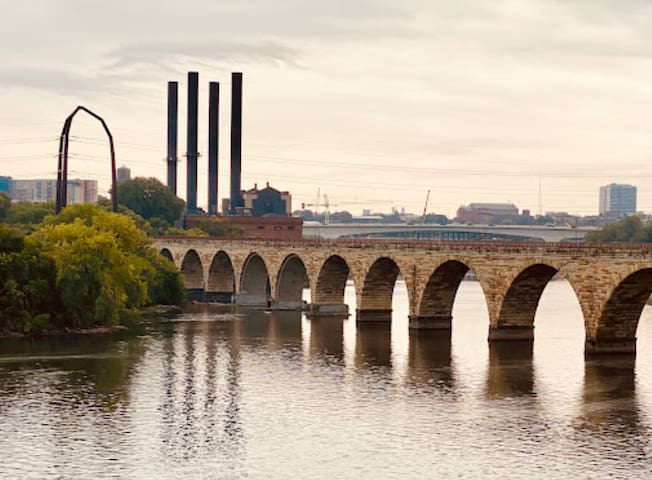
The signature feature of this trail is the Stone Arch Bridge, which is the only one of its kind over the Mississippi River. Built in 1883 by the Great Northern Railway tycoon James J. Hill, it facilitated the movement of people and goods across the river by rail until 1978. Consisting of 23 arches made from native granite and limestone, the 28-foot side bridge stretches for 2,100 feet, spanning the Mississippi River below St. Anthony Falls.
The bridge provided a link between the midway section of Saint Paul and the East Bank Mills in Minneapolis. It was also part of the region’s early railroad network, which made each train line responsible for finding its own route into Union Depot in downtown Minneapolis. Designated as a national Historical Civil Engineering Landmark, the Stone Arch Bridge sat idle for more than a decade beginning in the 1980s. A group of private and public organizations began refurbishing the landmark, which reopened as a pedestrian/bike bridge in 1994.
The short riverfront loop takes trail users across the bridge, providing a spectacular vantage point to view St. Anthony Falls immediately upriver from the span or downriver toward the University of Minnesota campus and the Dinkytown Greenway bridge, the next walk/bike bridge that crosses the river a short way downstream.
The trail passes next to Father Hennepin Bluff Park before following along Southeast Main Street, a riverfront section of retail shops and eateries. There is an option at Father Hennepin Bluff Park to head along streets toward the main university campus to the southeast, where trail users can link up with the Dinkytown Greenway trail that crosses the river about 0.75 mile to the southeast.
Otherwise, beyond these storefronts, the Heritage Trail crosses Nicollet Island, passing a pavilion on Merriam Street, before crossing the Hennepin Avenue Bridge back toward downtown Minneapolis.
Immediately down off the Hennepin Avenue Bridge, the trail passes through First Bridge Park on the West River Parkway for an opportunity to continue north, south (Minnehaha Falls is 6 miles away), and west to other major Minneapolis trail networks. Heading south along the West River Parkway Trail completes the loop at the trailhead/parking area for the Stone Arch Bridge, the lock, and the dam as well as other historic landmarks in this old mill district complex along the river.
Parking and Trail Access
From I-35W N. take Exit 18, and turn right onto University Ave. S.E. In 0.1 mile turn right onto 11th Ave. S.E., which becomes Second St. S.E. In 0.4 mile turn left onto Sixth Ave. S.E., and enter Father Hennepin Bluff Park. From I-35W S., take Exit 18, and turn right onto S.E. Fourth St. In 0.3 mile turn left onto Fifth Ave. S.E., and go 0.2 mile to the park.
From I-35W S., take Exit 17C. Turn right onto S. Washington Ave., and in 0.5 mile turn right onto Portland Ave. In 0.1 mile turn left onto W. River Pkwy. The Stone Arch Bridge parking area is on the right. From I-35W N., take Exit 16A, and keep left, following signs for downtown. Continue on MN 65 1 mile. Continue on Fifth Ave. S. 0.6 mile, and turn right onto S. Washington Ave. Immediately turn left onto Portland Ave. S., and in 0.1 mile turn left onto W. River Pkwy. The Stone Arch Bridge parking area is on the right.
18 personas locales recomiendan

Saint Anthony Falls
The signature feature of this trail is the Stone Arch Bridge, which is the only one of its kind over the Mississippi River. Built in 1883 by the Great Northern Railway tycoon James J. Hill, it facilitated the movement of people and goods across the river by rail until 1978. Consisting of 23 arches made from native granite and limestone, the 28-foot side bridge stretches for 2,100 feet, spanning the Mississippi River below St. Anthony Falls.
The bridge provided a link between the midway section of Saint Paul and the East Bank Mills in Minneapolis. It was also part of the region’s early railroad network, which made each train line responsible for finding its own route into Union Depot in downtown Minneapolis. Designated as a national Historical Civil Engineering Landmark, the Stone Arch Bridge sat idle for more than a decade beginning in the 1980s. A group of private and public organizations began refurbishing the landmark, which reopened as a pedestrian/bike bridge in 1994.
The short riverfront loop takes trail users across the bridge, providing a spectacular vantage point to view St. Anthony Falls immediately upriver from the span or downriver toward the University of Minnesota campus and the Dinkytown Greenway bridge, the next walk/bike bridge that crosses the river a short way downstream.
The trail passes next to Father Hennepin Bluff Park before following along Southeast Main Street, a riverfront section of retail shops and eateries. There is an option at Father Hennepin Bluff Park to head along streets toward the main university campus to the southeast, where trail users can link up with the Dinkytown Greenway trail that crosses the river about 0.75 mile to the southeast.
Otherwise, beyond these storefronts, the Heritage Trail crosses Nicollet Island, passing a pavilion on Merriam Street, before crossing the Hennepin Avenue Bridge back toward downtown Minneapolis.
Immediately down off the Hennepin Avenue Bridge, the trail passes through First Bridge Park on the West River Parkway for an opportunity to continue north, south (Minnehaha Falls is 6 miles away), and west to other major Minneapolis trail networks. Heading south along the West River Parkway Trail completes the loop at the trailhead/parking area for the Stone Arch Bridge, the lock, and the dam as well as other historic landmarks in this old mill district complex along the river.
Parking and Trail Access
From I-35W N. take Exit 18, and turn right onto University Ave. S.E. In 0.1 mile turn right onto 11th Ave. S.E., which becomes Second St. S.E. In 0.4 mile turn left onto Sixth Ave. S.E., and enter Father Hennepin Bluff Park. From I-35W S., take Exit 18, and turn right onto S.E. Fourth St. In 0.3 mile turn left onto Fifth Ave. S.E., and go 0.2 mile to the park.
From I-35W S., take Exit 17C. Turn right onto S. Washington Ave., and in 0.5 mile turn right onto Portland Ave. In 0.1 mile turn left onto W. River Pkwy. The Stone Arch Bridge parking area is on the right. From I-35W N., take Exit 16A, and keep left, following signs for downtown. Continue on MN 65 1 mile. Continue on Fifth Ave. S. 0.6 mile, and turn right onto S. Washington Ave. Immediately turn left onto Portland Ave. S., and in 0.1 mile turn left onto W. River Pkwy. The Stone Arch Bridge parking area is on the right.
This paved trail links Minneapolis’s Warehouse District to both the Minnesota River Bluffs LRT Regional Trail and the Cedar Lake LRT Regional Trail in Hopkins. It also intersects the Kenilworth Trail as part of the Cedar Lake Loop and a trail spur of the Luce Line State Trail coming down south from Theodore Wirth Regional Park along the Bassett Creek Regional Trail.
The trail is mostly urban at the eastern terminus at its junction with the West River Parkway, where the City of Minneapolis segment is most often called the Cedar Lake Trail. As it heads southwest, it passes a more serene landscape through Minneapolis’s wooded suburbs. The trail also links many neighborhood parks along the way. From St. Louis Park, where the trail crosses MN 100, to Hopkins, the trail is officially named the North Cedar Lake Regional Trail.
A part of the trail actually consists of three separate paths: two unidirectional paths for bicyclists and a multidirectional trail for pedestrians. Near the trail’s midpoint, bikers and runners will pass the trail’s namesake lake. Just east of Cedar Lake, the Kenilworth Trail begins, which takes trail users through the ritzy Kenwood neighborhood to the Cedar Lake LRT Regional Trail. Some consider this to be the nicest part of the trail.
You can also pick up the Luce Line Trail where the North Cedar Lake Regional Trail passes Bryn Mawr Meadows Park to continue on a much longer journey westward. This eastern section of the Luce Line Trail opened in 2002.
In Minneapolis, the trail, often referred to as the bike freeway, runs under Target Field—home to the Minnesota Twins—and immediately next to its rail station. At the trail’s terminus in north Minneapolis, connect to the West River Parkway Trail for a pleasant ride or run along the Mississippi River.
Parking and Trail Access
In Hopkins park in the lot at the Depot Coffee House. Take I-394 to Exit 3, and follow US 169 4.2 miles south. Take the Excelsior Blvd./County Road 3 exit. Turn left onto Excelsior Blvd. The coffee house will be on your right in 0.2 mile.
Unofficial parking areas for trail access can be found in Aquila Park on W. 31st St. near Aquila Ave.; just off Virginia Ave. S. at Victoria Lake; St. Louis Park at Nelson and Dakota Parks on W. 26th St. near Dakota Ave.; and at the eastern terminus just south of N. Fourth Ave. near First Bridge Park.

North Cedar Lake Regional Trail
North Cedar Lake Regional TrailThis paved trail links Minneapolis’s Warehouse District to both the Minnesota River Bluffs LRT Regional Trail and the Cedar Lake LRT Regional Trail in Hopkins. It also intersects the Kenilworth Trail as part of the Cedar Lake Loop and a trail spur of the Luce Line State Trail coming down south from Theodore Wirth Regional Park along the Bassett Creek Regional Trail.
The trail is mostly urban at the eastern terminus at its junction with the West River Parkway, where the City of Minneapolis segment is most often called the Cedar Lake Trail. As it heads southwest, it passes a more serene landscape through Minneapolis’s wooded suburbs. The trail also links many neighborhood parks along the way. From St. Louis Park, where the trail crosses MN 100, to Hopkins, the trail is officially named the North Cedar Lake Regional Trail.
A part of the trail actually consists of three separate paths: two unidirectional paths for bicyclists and a multidirectional trail for pedestrians. Near the trail’s midpoint, bikers and runners will pass the trail’s namesake lake. Just east of Cedar Lake, the Kenilworth Trail begins, which takes trail users through the ritzy Kenwood neighborhood to the Cedar Lake LRT Regional Trail. Some consider this to be the nicest part of the trail.
You can also pick up the Luce Line Trail where the North Cedar Lake Regional Trail passes Bryn Mawr Meadows Park to continue on a much longer journey westward. This eastern section of the Luce Line Trail opened in 2002.
In Minneapolis, the trail, often referred to as the bike freeway, runs under Target Field—home to the Minnesota Twins—and immediately next to its rail station. At the trail’s terminus in north Minneapolis, connect to the West River Parkway Trail for a pleasant ride or run along the Mississippi River.
Parking and Trail Access
In Hopkins park in the lot at the Depot Coffee House. Take I-394 to Exit 3, and follow US 169 4.2 miles south. Take the Excelsior Blvd./County Road 3 exit. Turn left onto Excelsior Blvd. The coffee house will be on your right in 0.2 mile.
Unofficial parking areas for trail access can be found in Aquila Park on W. 31st St. near Aquila Ave.; just off Virginia Ave. S. at Victoria Lake; St. Louis Park at Nelson and Dakota Parks on W. 26th St. near Dakota Ave.; and at the eastern terminus just south of N. Fourth Ave. near First Bridge Park.
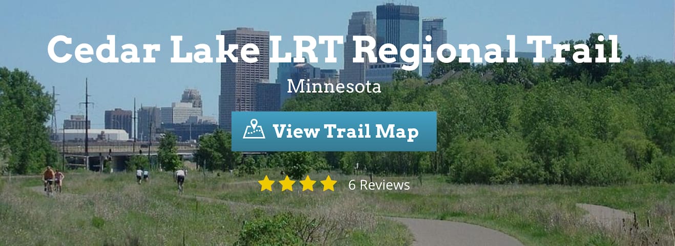
The Cedar Lake Light Rail Transit (LRT) Regional Trail is an integral component of Hennepin County’s extensive trail network, in which rail-trails feature prominently. The trail directly links four trails together: In the west, it branches off at the junction of both the similarly named North Cedar Lake Regional Trail and the Minnesota River Bluffs LRT Regional Trail. The eastern end of the Cedar Lake LRT Regional Trail seamlessly becomes Minneapolis’s popular Midtown Greenway just north of Excelsior Boulevard, where Chowen Avenue South curves to become Abbott Avenue South. Just a few hundred yards north, it links up with the Kenilworth Trail (whose southern segment is also known as the Burnham Trail). Taking the Kenilworth Trail north enables users to link up with the North Cedar Lake Regional Trail and continue into downtown Minneapolis for even more trail connections. Heading back west along the North Cedar Lake Regional Trail leads to the western terminus in Hopkins as part of the 12-mile Cedar Lake Loop.
Running past mostly industrial properties, the 12-foot-wide, paved Cedar Lake LRT Regional Trail occupies a former Minneapolis and St. Louis Railway (and later Chicago and North Western Railway) corridor. The right-of-way became inactive in the early 1990s and was acquired by the Hennepin County Regional Railroad Authority (HCRRA), which installed the trail. The HCRRA always planned to use the corridor for a future passenger rail line; in fact, the LRT designation of several Hennepin County trails indicates those pathways built on corridors intended for future light rail transit use.
Fortunately, even though the planned Southwest LRT line will run on the entirety of what is now the Cedar Lake LRT Regional Trail, the HCRRA has committed to maintaining all existing trails. In this case, the trail will become one of an ever-increasing number of successful rail-with-trail projects around the country.
Parking and Trail Access
To begin at the western end of the Cedar Lake LRT Regional Trail in Hopkins, park at the Depot Coffee House and trailhead, which lies immediately south of the trail on a spur that connects to the Minnesota River Bluffs LRT Regional Trail between Excelsior Blvd. and Milwaukee St. Take I-394 to Exit 3, and follow US 169 4.2 miles south. Take the Excelsior Blvd./County Road 3 exit. Turn left onto Excelsior Blvd. The coffee house will be on your right in 0.2 mile. The trail begins across the road.
Heading east out of Hopkins, there is also a large parking lot at the Sam’s Club, immediately north of the trail access, on Louisiana Ave. S. in St. Louis Park. Take I-394 to Exit 5, and merge onto MN 100. Follow it 1.8 miles south, and take the W. 36th St. exit. Turn right onto Wooddale Ave. S., and in 0.4 mile turn left onto MN 7. In 0.3 mile take the Louisiana Ave. exit. Turn left onto Louisiana Ave., and in 0.1 mile Sam’s Club will be on the left. The trail is at the southern end of the parking lot.
For access to the eastern end, take I-394 to Exit 5, and merge onto MN 100. Follow it 1.4 miles south, and take the CR 5/Minnetonka Blvd. exit. Turn left onto Minnetonka Blvd., and go 0.9 mile. Turn left onto CR 25, and in 0.6 mile make a sharp right onto Excelsior Blvd. Turn right onto Abbott Ave., where you can likely find parking along the street. The trail is in 0.2 mile, where Abbott meets Chowen Ave.
38 personas locales recomiendan
Cedar Lake Point Beach
Cedar Lake ParkwayThe Cedar Lake Light Rail Transit (LRT) Regional Trail is an integral component of Hennepin County’s extensive trail network, in which rail-trails feature prominently. The trail directly links four trails together: In the west, it branches off at the junction of both the similarly named North Cedar Lake Regional Trail and the Minnesota River Bluffs LRT Regional Trail. The eastern end of the Cedar Lake LRT Regional Trail seamlessly becomes Minneapolis’s popular Midtown Greenway just north of Excelsior Boulevard, where Chowen Avenue South curves to become Abbott Avenue South. Just a few hundred yards north, it links up with the Kenilworth Trail (whose southern segment is also known as the Burnham Trail). Taking the Kenilworth Trail north enables users to link up with the North Cedar Lake Regional Trail and continue into downtown Minneapolis for even more trail connections. Heading back west along the North Cedar Lake Regional Trail leads to the western terminus in Hopkins as part of the 12-mile Cedar Lake Loop.
Running past mostly industrial properties, the 12-foot-wide, paved Cedar Lake LRT Regional Trail occupies a former Minneapolis and St. Louis Railway (and later Chicago and North Western Railway) corridor. The right-of-way became inactive in the early 1990s and was acquired by the Hennepin County Regional Railroad Authority (HCRRA), which installed the trail. The HCRRA always planned to use the corridor for a future passenger rail line; in fact, the LRT designation of several Hennepin County trails indicates those pathways built on corridors intended for future light rail transit use.
Fortunately, even though the planned Southwest LRT line will run on the entirety of what is now the Cedar Lake LRT Regional Trail, the HCRRA has committed to maintaining all existing trails. In this case, the trail will become one of an ever-increasing number of successful rail-with-trail projects around the country.
Parking and Trail Access
To begin at the western end of the Cedar Lake LRT Regional Trail in Hopkins, park at the Depot Coffee House and trailhead, which lies immediately south of the trail on a spur that connects to the Minnesota River Bluffs LRT Regional Trail between Excelsior Blvd. and Milwaukee St. Take I-394 to Exit 3, and follow US 169 4.2 miles south. Take the Excelsior Blvd./County Road 3 exit. Turn left onto Excelsior Blvd. The coffee house will be on your right in 0.2 mile. The trail begins across the road.
Heading east out of Hopkins, there is also a large parking lot at the Sam’s Club, immediately north of the trail access, on Louisiana Ave. S. in St. Louis Park. Take I-394 to Exit 5, and merge onto MN 100. Follow it 1.8 miles south, and take the W. 36th St. exit. Turn right onto Wooddale Ave. S., and in 0.4 mile turn left onto MN 7. In 0.3 mile take the Louisiana Ave. exit. Turn left onto Louisiana Ave., and in 0.1 mile Sam’s Club will be on the left. The trail is at the southern end of the parking lot.
For access to the eastern end, take I-394 to Exit 5, and merge onto MN 100. Follow it 1.4 miles south, and take the CR 5/Minnetonka Blvd. exit. Turn left onto Minnetonka Blvd., and go 0.9 mile. Turn left onto CR 25, and in 0.6 mile make a sharp right onto Excelsior Blvd. Turn right onto Abbott Ave., where you can likely find parking along the street. The trail is in 0.2 mile, where Abbott meets Chowen Ave.
The 5.5-mile Midtown Greenway follows a former railroad corridor through the heart of south Minneapolis, heading due west from the Mississippi River to the neighborhood of West Calhoun in the scenic Chain of Lakes area. The paved pathway is only one block north of the improving Lake Street corridor and runs parallel to the road for most of its route, thus providing a safe alternative for cyclists and pedestrians to travel instead of the busy street.
Much of the trail is below grade because of a 1912 mandate by the Minneapolis City Council for the Milwaukee Road to dig a trench for its rail line. Presently, the decision ensures that trail users have minimal contact with vehicular traffic. East of MN 55/Hiawatha Avenue, the Minnesota Commercial Railway operates trains on the corridor to this day.
This section of the Midtown Greenway is an example of a successful rail-with-trail project. Busy Hiawatha Avenue is crossed via the stunning Martin Olav Sabo Bridge, which is exclusively for bicycle and pedestrian use. Just east of the bridge, trail users can pick up the Hiawatha Trail to travel north to downtown Minneapolis or south to Minnehaha.
On its western end, the Midtown Greenway connects directly to the Cedar Lake LRT Regional Trail, which links Minneapolis to the suburbs of St. Louis Park, Hopkins, and beyond via other connecting trails. Traveling north on the Kenilworth Trail—also located at the Midtown Greenway’s western end—leads trail users to the longer North Cedar Lake Regional Trail. East of Hiawatha Avenue, a short segment of the trail is above ground; to the west through much of south Minneapolis, it runs below street level.
In the east, bicyclists and pedestrians can join the West River Parkway Trail for a longer ride, run, or walk along the Mississippi River. Just a few blocks east of the intersection with the West River Parkway, a ramp at Brackett Field Park lets users access/exit the trail. There is ample parking on nearby streets.
In the future, a streetcar line may be installed in the Midtown Greenway corridor, although a separated trail would still be maintained. There has also been local interest in extending the trail east over the Mississippi River into the Prospect Park neighborhood of Minneapolis and onward into Saint Paul.
The Midtown Greenway connects to the West River Parkway Trail, which users can take south to Minnehaha Regional Park or north to other trail intersections heading into downtown or across the river to the University of Minnesota.
Parking and Trail Access
To access parking at Brackett Field Park, take I-94 E. to Exit 235A toward Riverside Ave./25th Ave. Merge onto S. Ninth St., and then immediately turn right onto 26th Ave. S. In 0.5 mile turn left onto E. 25th St., and in another 0.7 mile turn right onto 36th Ave. S. Go 0.4 mile to E. 28th St., and in 0.2 mile turn left onto S. 39th Ave. to reach Brackett Field Park. The trail has multiple access points throughout downtown.
17 personas locales recomiendan

Midtown Greenway
Midtown GreenwayThe 5.5-mile Midtown Greenway follows a former railroad corridor through the heart of south Minneapolis, heading due west from the Mississippi River to the neighborhood of West Calhoun in the scenic Chain of Lakes area. The paved pathway is only one block north of the improving Lake Street corridor and runs parallel to the road for most of its route, thus providing a safe alternative for cyclists and pedestrians to travel instead of the busy street.
Much of the trail is below grade because of a 1912 mandate by the Minneapolis City Council for the Milwaukee Road to dig a trench for its rail line. Presently, the decision ensures that trail users have minimal contact with vehicular traffic. East of MN 55/Hiawatha Avenue, the Minnesota Commercial Railway operates trains on the corridor to this day.
This section of the Midtown Greenway is an example of a successful rail-with-trail project. Busy Hiawatha Avenue is crossed via the stunning Martin Olav Sabo Bridge, which is exclusively for bicycle and pedestrian use. Just east of the bridge, trail users can pick up the Hiawatha Trail to travel north to downtown Minneapolis or south to Minnehaha.
On its western end, the Midtown Greenway connects directly to the Cedar Lake LRT Regional Trail, which links Minneapolis to the suburbs of St. Louis Park, Hopkins, and beyond via other connecting trails. Traveling north on the Kenilworth Trail—also located at the Midtown Greenway’s western end—leads trail users to the longer North Cedar Lake Regional Trail. East of Hiawatha Avenue, a short segment of the trail is above ground; to the west through much of south Minneapolis, it runs below street level.
In the east, bicyclists and pedestrians can join the West River Parkway Trail for a longer ride, run, or walk along the Mississippi River. Just a few blocks east of the intersection with the West River Parkway, a ramp at Brackett Field Park lets users access/exit the trail. There is ample parking on nearby streets.
In the future, a streetcar line may be installed in the Midtown Greenway corridor, although a separated trail would still be maintained. There has also been local interest in extending the trail east over the Mississippi River into the Prospect Park neighborhood of Minneapolis and onward into Saint Paul.
The Midtown Greenway connects to the West River Parkway Trail, which users can take south to Minnehaha Regional Park or north to other trail intersections heading into downtown or across the river to the University of Minnesota.
Parking and Trail Access
To access parking at Brackett Field Park, take I-94 E. to Exit 235A toward Riverside Ave./25th Ave. Merge onto S. Ninth St., and then immediately turn right onto 26th Ave. S. In 0.5 mile turn left onto E. 25th St., and in another 0.7 mile turn right onto 36th Ave. S. Go 0.4 mile to E. 28th St., and in 0.2 mile turn left onto S. 39th Ave. to reach Brackett Field Park. The trail has multiple access points throughout downtown.
Parks + Sights
Enjoy walking in the park and seeing the sculptures. Zero cost!
606 personas locales recomiendan
Walker Art Center
725 Vineland PlEnjoy walking in the park and seeing the sculptures. Zero cost!
This historic bridge is a perfect scenic walk with views of the river, city, and wonderful people watching.
250 personas locales recomiendan
Stone Arch Bridge
100 Portland AveThis historic bridge is a perfect scenic walk with views of the river, city, and wonderful people watching.
An absolute MUST-SEE with lots of trails for walking/running and stairs if you want to get in a great stair workout.
613 personas locales recomiendan
Minnehaha Falls
4801 S Minnehaha DrAn absolute MUST-SEE with lots of trails for walking/running and stairs if you want to get in a great stair workout.
Great spot to swim, walk trails, or bike. Right in the epi-center of the city.
6 personas locales recomiendan
Boom Island
Great spot to swim, walk trails, or bike. Right in the epi-center of the city.
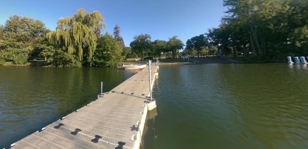
Lake Hiawatha Park
2701 E 44th StA nice swim or just a walk/run around the lake.
Lovely spot to walk the lake near the bustle of uptown or rent a kayak, paddleboard, or paddleboat in the summer. Not the best swimming. Try Cedar Lake nearby for that.
375 personas locales recomiendan
Bde Maka Ska
West Bde Maka Ska ParkwayLovely spot to walk the lake near the bustle of uptown or rent a kayak, paddleboard, or paddleboat in the summer. Not the best swimming. Try Cedar Lake nearby for that.
My favorite city lake to swim in. You can rent kayaks, paddleboards, paddleboats, or canoes at Bde Maka Ska nearby and use the lake channels to go from Isles over to Cedar and then to lesser-known Brownie Lake.
38 personas locales recomiendan
Cedar Lake Point Beach
Cedar Lake ParkwayMy favorite city lake to swim in. You can rent kayaks, paddleboards, paddleboats, or canoes at Bde Maka Ska nearby and use the lake channels to go from Isles over to Cedar and then to lesser-known Brownie Lake.
Music in the park in the summer. A quick 3 mile run around the lake is fun. Sailboats make this lake so pretty, I wouldn't recommend swimming in it.
185 personas locales recomiendan
Lake Harriet
4135 W Lake Harriet PkwyMusic in the park in the summer. A quick 3 mile run around the lake is fun. Sailboats make this lake so pretty, I wouldn't recommend swimming in it.
This is a beautiful park near downtown and the Walker Art center. Fun to walk around and people watch. Walk across the bridge to go through the sculpture gardens.
67 personas locales recomiendan
Loring Park
This is a beautiful park near downtown and the Walker Art center. Fun to walk around and people watch. Walk across the bridge to go through the sculpture gardens.